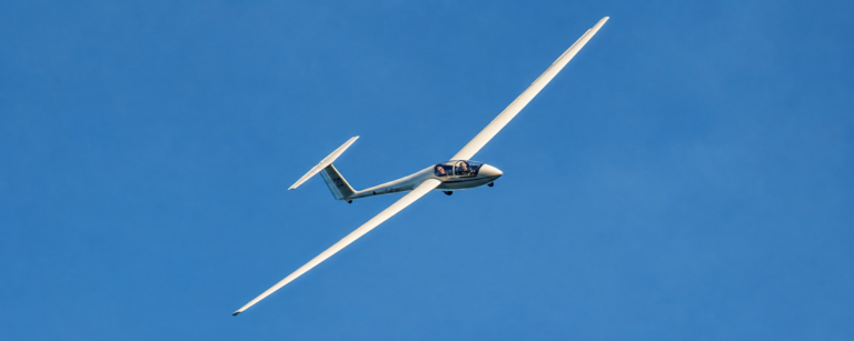
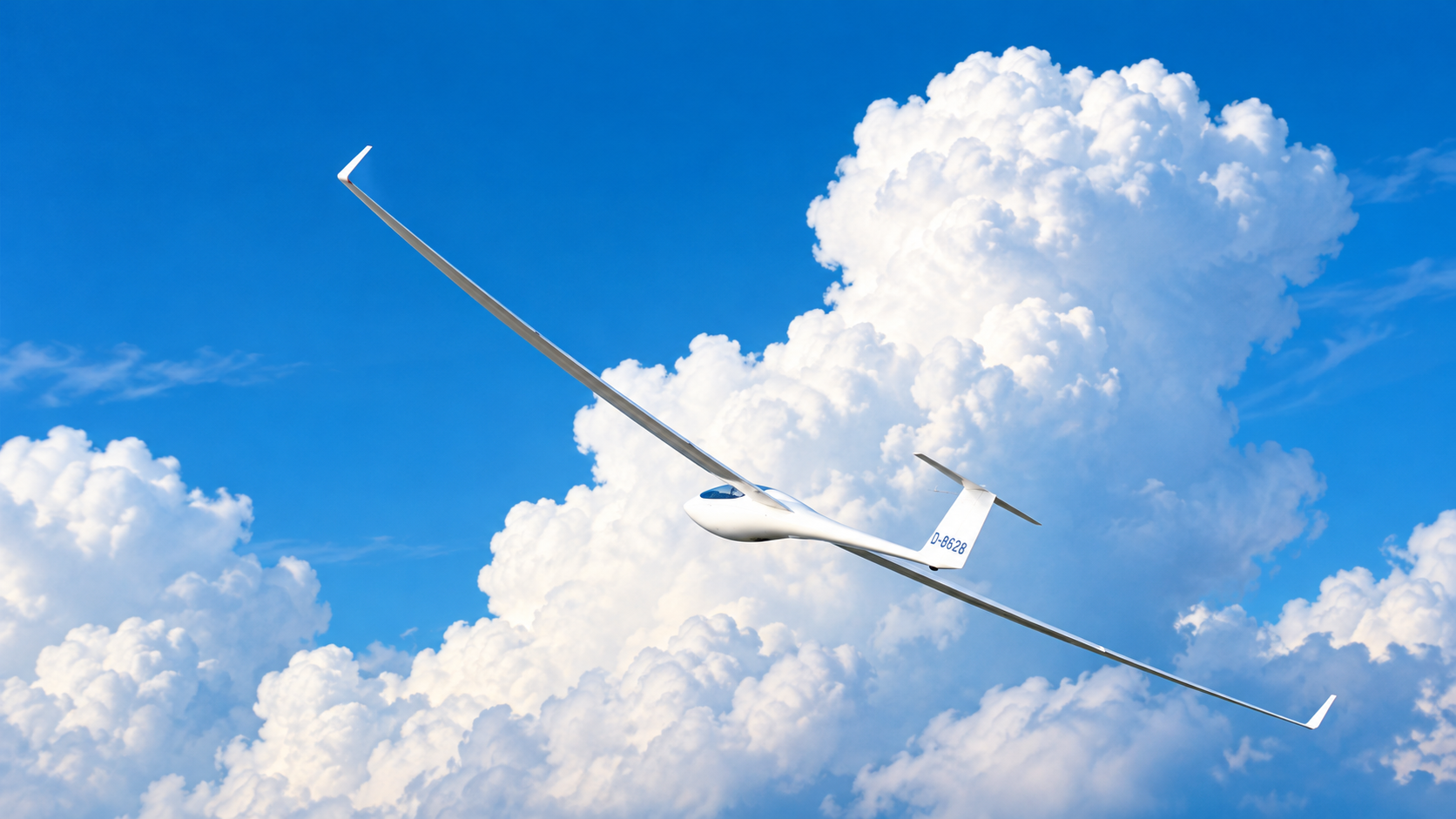

The best weather for gliding is weather that provides usable lift, manageable wind, good visibility, and enough time for a safe flight and landing. However, the ideal conditions depend on the type of soaring you want to do, the local terrain, and your experience level.
Imagine arriving at a gliding club on a bright, sunny morning. The sky looks beautiful, the wind seems light, and everything appears perfect for flying. Yet the glider may struggle to climb because the air is not rising strongly enough to provide useful lift. On another day, scattered clouds may mark areas of rising air, allowing a glider to climb and remain airborne for hours.
This is one of the fascinating things about gliding. Beautiful weather does not always mean good soaring weather. What matters is how the atmosphere behaves, how the wind interacts with the landscape, and whether the available conditions suit the flight you want to make.
For beginners, understanding the weather is an essential part of learning to fly. This guide explains the main weather conditions that help gliders stay airborne, how to recognise useful signs in the sky, and which conditions require extra caution.
If you are new to the sport, start with our guide to gliding basics to understand how gliders fly before exploring how weather affects their performance.
Why Does Weather Matter in Gliding?
Unlike powered aircraft, most gliders do not have an engine to maintain altitude or climb whenever the pilot wants. After launch, a glider gradually loses height while moving through the air unless it finds rising air that can help it climb.
The key is to find air that rises faster than the glider is descending through it. When the surrounding air rises sufficiently, the glider can gain altitude. Pilots call this rising air lift.
A glider pilot may use several types of lift:
- Thermal lift: Rising air heated by the ground.
- Ridge lift: Air pushed upward as wind flows against a hill or mountain.
- Mountain wave lift: Rising air associated with atmospheric waves that form downwind of mountain ranges under suitable conditions.
Each type depends on different weather patterns. Sunny conditions often favour thermal soaring, while suitable wind and terrain can produce ridge lift. Mountain waves require a particular combination of wind, atmospheric stability, and terrain.
A variometer indicates the glider’s rate of climb or descent. This helps pilots recognise lift and sink, although a basic variometer does not independently measure the vertical movement of the surrounding air. A total energy compensated variometer helps reduce indications caused by exchanges between airspeed and altitude, making it more useful for assessing changes in the air mass.
Weather knowledge remains essential. Instruments can help pilots recognise what is happening, but understanding the atmosphere helps them anticipate where lift may develop.
Sunshine and Thermals: A Classic Combination
For many glider pilots, sunny weather with developing thermals provides some of the most rewarding flying conditions.
A thermal begins when sunlight heats the ground unevenly. The ground then warms the air immediately above it. If this air becomes warmer and less dense than the surrounding air, it may begin to rise.
As the rising air continues upward, it expands and cools because atmospheric pressure decreases with altitude. If the air remains warmer than its surroundings, it can keep rising and provide lift for a glider.
Not every sunny day produces strong thermals. Their strength and development depend on surface heating, atmospheric stability, moisture, and the temperature structure of the air above the ground.
What Makes Thermals Stronger?
Thermals are often more useful when:
- The sun provides enough energy to heat the ground.
- The atmosphere allows warm air to continue rising.
- Different surfaces heat at different rates, helping thermals develop in particular areas.
- The conditions are not so turbulent or gusty that they become unsuitable for the pilot or aircraft.
Dry fields, ploughed land, rocky areas, and urban surfaces can heat differently from forests, lakes, or wet ground. This uneven heating can influence where thermals form, although it does not guarantee usable lift at any particular location.
For a closer look at how pilots find and use rising air, read our guide to soaring and thermals.
What Is Trigger Temperature?
Trigger temperature is a forecasting concept used to estimate the surface temperature at which thermals may begin developing under a particular atmospheric profile.
As the ground heats the air above it, thermals may begin when surface heating becomes sufficient for rising parcels of air to overcome the atmosphere’s resistance to vertical motion. Forecasts may provide a trigger temperature to help pilots estimate when useful convection could begin.
Reaching the trigger temperature does not guarantee strong thermals. Cloud cover, changing winds, soil moisture, atmospheric stability, and local terrain can all affect the result. Trigger temperature should be interpreted alongside the full forecast rather than treated as a guaranteed starting point for soaring.
Are Clouds Necessary for Thermal Soaring?
No. Thermals can develop without producing visible clouds.
When rising air contains enough moisture and cools to its dew point, water vapour condenses into tiny droplets and a cumulus cloud may form. The cloud can provide a visible clue to rising air below it.
On drier days, the air may rise without reaching the point where a cloud forms. These are often called blue thermals because the sky remains blue above them.
This means a cloudless sky does not automatically rule out good thermal soaring. Pilots must learn to assess the forecast, the surrounding terrain, atmospheric conditions, and other possible signs of rising air.
How Do Pilots Turn Inside a Thermal?
When a pilot finds usable lift, the glider is often flown in a sustained turn to remain within the rising air. The pilot must maintain appropriate airspeed, coordinate the controls, and adjust the turn as the thermal changes.
Turning too steeply or flying too slowly can reduce the margin above the stall. Turbulence can also make the glider’s response less predictable.
Our guide to glider turning techniques explains the fundamentals of coordinated turns and why smooth, controlled flying matters when circling in lift.
A Variometer is another useful instrument during thermal soaring. It helps the pilot assess whether the glider is climbing or descending and whether adjustments may be needed. The pilot must still combine instrument indications with visual observation and sound flying technique.
Clouds and Cloud Base: Reading the Sky
Clouds provide valuable information about the atmosphere, but not every cloud indicates good soaring conditions.
Small, well-defined cumulus clouds can indicate that thermals are reaching the level where water vapour condenses. When conditions remain favourable, these clouds may continue developing as rising air feeds them.
However, the appearance of a cloud can change quickly. A cloud that once marked useful lift may begin to dissipate, and the air beneath it may no longer provide the same climb.
What Is Cloud Base?
Cloud base is the height of the lowest part of a cloud, where rising air has cooled to its dew point.
For glider pilots, cloud base matters because it can limit how high they can climb while remaining legally and safely outside cloud. The actual restrictions depend on the airspace, applicable aviation rules, visibility, and required separation from clouds.
A higher cloud base can provide more vertical room for thermal soaring, but it does not guarantee strong thermals or a long flight. Lift strength, wind, visibility, airspace restrictions, and the pilot’s decisions remain important.
Which Clouds Are More Useful?
Developing cumulus clouds
Small cumulus clouds with clearly defined edges can indicate active convection. Their bases may help pilots identify areas where thermals are reaching the condensation level.
Dissipating cumulus clouds
Clouds that lose their definition and begin breaking apart may indicate weakening convection. However, cloud appearance alone cannot reliably establish the strength of the air below it.
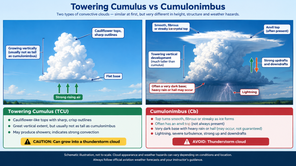
Towering cumulus clouds
Rapidly growing clouds with substantial vertical development can indicate powerful convection. They may develop into thunderstorms, so pilots must pay close attention to forecasts and changing conditions.
Low cloud and overcast skies
Low cloud can restrict visibility and reduce the height available for soaring. Extensive cloud cover may also limit surface heating, although the effect depends on the cloud type, thickness, and atmospheric situation.
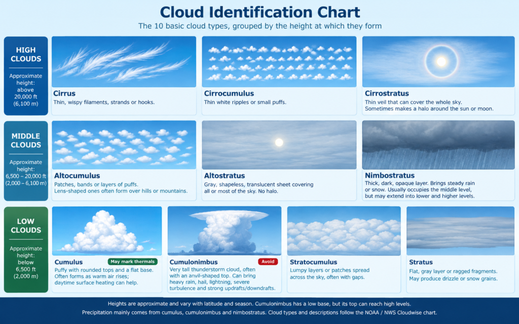
The most useful approach is to observe how the sky develops over time rather than judging conditions from a single glance.
Wind Conditions: How Much Wind Is Best?
There is no single wind speed that is ideal for every glider flight. The best wind conditions depend on the type of soaring, the launch method, the terrain, the glider, and the pilot’s experience.
For a beginner, manageable wind with predictable direction and limited gustiness is often more suitable than strong, turbulent wind. However, light wind does not necessarily mean good soaring conditions.
Wind for Thermal Soaring
Thermals can form in a range of wind conditions. Wind affects their shape and position, often carrying rising air downwind as it develops.
A moderate wind may help organise thermals in some situations, but stronger winds can tilt and spread them, making them harder to locate or use. Gusty conditions can also create turbulence and make handling more demanding.
Cross-country pilots must consider wind direction and speed at different altitudes, not just the wind at the airfield. Wind can affect ground speed, route planning, glide range over the ground, and the time needed to return.
Wind for Ridge Soaring
Ridge soaring generally requires wind to blow toward a suitable ridge so that the terrain forces some of the air upward.
The wind direction must be appropriate for the ridge’s orientation. Wind that is too weak may provide insufficient lift, while strong or turbulent wind can create challenging conditions, particularly near the terrain.
Local topography can produce rotor turbulence, wind shear, and other hazards. Ridge soaring therefore requires appropriate training, careful planning, and a clear understanding of the local environment.
Why Gusts Matter
Wind speed is only one part of the picture. A steady wind and a gusty wind of the same average speed can produce very different flying experiences.
Rapid changes in wind speed or direction can make a glider harder to control, particularly close to the ground during launch and landing. Beginners should follow their instructor’s guidance and the club’s operating limits rather than deciding that a particular wind speed is safe based on a general rule.
Temperature and Atmospheric Stability
Temperature affects how air moves vertically, which makes it central to understanding gliding weather.
When air near the ground becomes warmer than the air around it, it may rise. Whether it continues rising depends partly on how its temperature compares with the surrounding atmosphere as it climbs.
This relationship is known as atmospheric stability.
Unstable Air
In an unstable atmosphere, rising air can remain warmer than the surrounding air and continue upward. When sufficient surface heating is available, this can support thermal development.
Unstable conditions can help produce strong soaring lift, but they may also lead to rough thermals, rapidly growing clouds, and thunderstorms. Stronger convection is not automatically safer or better.
Stable Air
In a stable atmosphere, vertically moving air tends to return toward its original level rather than continuing to rise freely. This can limit thermal development even when the sky appears sunny.
Stable air is not always unsuitable for gliding. Under the right wind and terrain conditions, stable layers can be important in the formation of mountain waves.
This is why the same weather feature can be helpful for one type of soaring but less favourable for another. Pilots need to understand the complete weather pattern rather than looking for one condition in isolation.
What Is the Best Time of Day for Gliding?
For thermal soaring, the most useful period often begins after the sun has warmed the ground sufficiently and thermals have started developing.
In many locations, thermal activity increases through the morning, becomes stronger around the middle of the day or afternoon, and weakens later as surface heating decreases. The exact timing depends on season, latitude, cloud cover, terrain, and the local weather pattern.
Morning
Early morning can be excellent for training flights because the air is often relatively smooth before strong daytime convection develops. Overnight cooling can create a stable layer or temperature inversion near the ground, limiting vertical mixing and thermal activity.
This can make conditions more comfortable for practising basic handling, although the suitability of a training flight still depends on wind, visibility, cloud base, and the instructor’s assessment.
A smooth flight does not necessarily mean a flight with strong soaring lift. Thermal activity may remain limited until the sun has heated the ground sufficiently.
Midday and Afternoon
As the ground receives more solar energy, thermals can become more developed. Under favourable conditions, this period may provide opportunities for longer flights and cross-country soaring.
The strongest part of the day can also bring rougher thermals, higher cloud development, and a greater risk of thunderstorms in unstable air. Pilots must assess both the potential lift and the associated hazards.
Late Afternoon and Evening
As sunshine decreases, surface heating weakens and thermals often become less reliable. A pilot who is away from the airfield must allow enough time to return and land safely.
Late-day flights can still be enjoyable, but pilots should not assume that useful lift will remain available until sunset. Planning must account for the actual weather, daylight, landing options, and the pilot’s experience.
Humidity, Rain, Wet Wings and Thunderstorms
Moisture in the atmosphere influences cloud formation and can help pilots interpret the sky. However, humidity alone does not determine whether the weather is suitable for gliding.
When rising air cools to its dew point, water vapour can condense into cloud droplets. If there is sufficient moisture and vertical development, clouds may grow into towering cumulus or cumulonimbus.
Is Rain Good for Gliding?
Persistent rain is generally unfavourable for ordinary recreational and training gliding. It can reduce visibility, affect the launch and landing environment, and signal weather conditions that are unsuitable for the planned flight.
Rain also creates an important aerodynamic consideration: a wet wing can affect glider performance and stall behaviour. Water on the wing surface can disturb the airflow and change the wing’s aerodynamic characteristics. Depending on the glider design and the nature of the contamination, this may reduce performance and alter the stall characteristics.
The effect is aircraft-specific, so pilots should follow the flight manual and the manufacturer’s guidance for the particular glider. Do not assume that a wet wing is harmless or that familiar stall speeds and handling responses will remain unchanged in all conditions.
Why Thunderstorms Are Dangerous
Thunderstorms can produce severe hazards, including lightning, hail, strong updrafts and downdrafts, severe turbulence, heavy precipitation, and sudden changes in wind. Dangerous air movements can extend beyond the visible cloud, and the visible appearance of a thunderstorm is not a reliable guide to the severity of its internal conditions.
Glider pilots should avoid thunderstorms and threatening convective cloud, following official forecasts, local procedures, and instructor guidance.
For further reading, consult the Federal Aviation Administration’s Aeronautical Information Manual, Chapter 7: Safety of Flight, Section 1: Meteorology. This chapter covers aviation meteorology more broadly, including weather hazards relevant to flight planning.
Ridge Lift and Mountain Wave Conditions
Thermals are not the only source of lift available to glider pilots. In areas with suitable terrain, wind can create other forms of rising air.
Ridge Lift
When wind flows toward a hill or mountain ridge, the terrain can force the air upward along the windward slope. A glider can use this rising air to maintain or gain altitude.
The most favourable wind direction is generally one that carries air toward the ridge rather than parallel to it. The ridge shape, wind strength, turbulence, and surrounding terrain all affect the result.
Ridge soaring can allow pilots to fly along a ridge for extended periods, but it also requires careful attention to terrain clearance, wind changes, and escape routes.
Mountain Wave
Mountain waves can form when wind flows across a mountain range in a suitable atmospheric environment, often involving stable air and wind that is approximately perpendicular to the range. Wind speed and direction with height influence whether useful waves develop. In favourable wave conditions, wind speed often increases with altitude, although the complete vertical wind profile and atmospheric stability both matter.
These waves can produce lift well above and downwind of the mountains. They may also be associated with severe turbulence, including rotor activity beneath parts of the wave system.
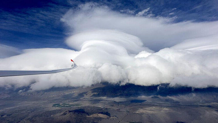
In some conditions, wave activity may be marked by smooth, lens-shaped lenticular clouds near the crest of the waves. These clouds can be a visual clue that a wave is present, but their absence does not prove there is no wave, and their presence does not make the area safe to fly. Rotor turbulence can occur beneath wave systems whether or not rotor clouds are visible.
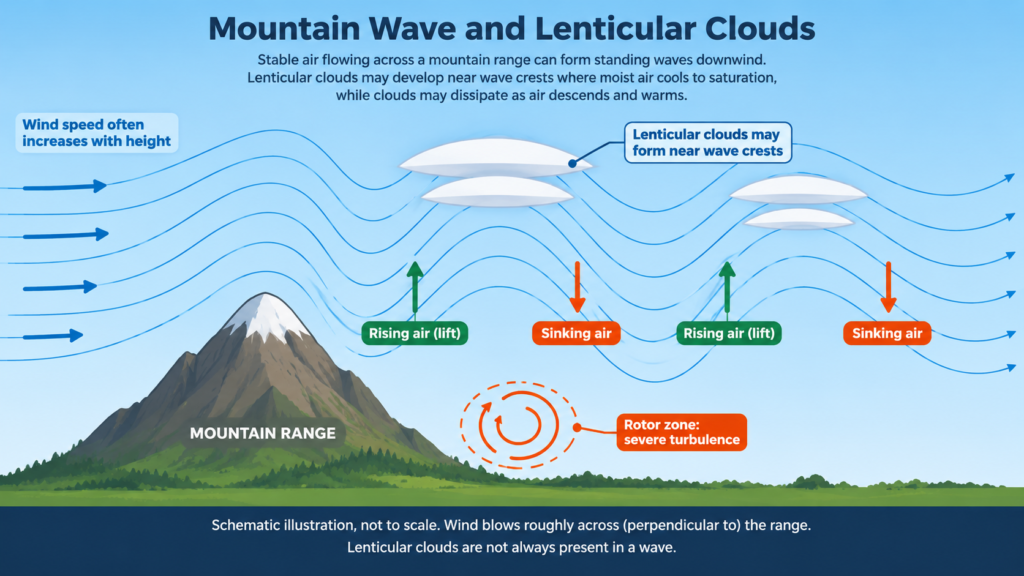
Mountain wave soaring can take gliders to very high altitudes, where additional hazards must be considered.
Oxygen and hypoxia: At altitude, reduced oxygen availability can impair judgement, coordination, and decision-making before a pilot fully recognises the problem. High-altitude wave flights may require supplemental oxygen under applicable regulations, and oxygen equipment must be suitable for the planned altitude and flight duration. Pilots need to understand the relevant oxygen requirements and hypoxia risks before attempting high-altitude soaring.
Airspace and ATC clearance: Mountain wave conditions do not give a pilot permission to enter restricted, prohibited, or controlled airspace without meeting the applicable requirements. Where an ATC clearance is required, it must be obtained before entering the relevant controlled airspace. Pilots must check current charts, airspace restrictions, weather, and local procedures as part of flight planning.
Icing and severe turbulence: Mountain wave environments can involve severe turbulence and, in suitable moisture and temperature conditions, icing. Pilots must assess the forecast icing risk and the aircraft’s limitations. A glider should not be flown into conditions beyond its approved capabilities or the pilot’s training and equipment.
Mountain wave soaring is not simply a matter of finding strong wind. It requires specialised knowledge, suitable equipment and aircraft, appropriate training, and careful planning.
What Is the Best Weather for Different Types of Gliding?
The best conditions vary with the type of flight a pilot wants to make.
| Type of gliding | Conditions that may be favourable | Important considerations |
|---|---|---|
| Training flights | Manageable wind, good visibility, suitable cloud ceiling | Instructor guidance, launch conditions, and safe landing options |
| Thermal soaring | Surface heating and an atmosphere that supports rising air | Thermal strength, cloud development, turbulence, and cloud base |
| Cross-country soaring | Sustained lift over a broad area and suitable visibility | Wind at altitude, route planning, airspace, and safe outlanding options |
| Ridge soaring | Wind blowing toward a suitable ridge | Terrain clearance, turbulence, wind strength, and escape routes |
| Mountain wave soaring | Suitable wind across mountains and a favourable stable atmospheric structure | Specialised training, oxygen requirements, icing and turbulence risks, airspace, and equipment |
No single forecast guarantees a good flight. Conditions must be assessed for the specific location, aircraft, pilot, and planned activity.
How to Read a Weather Forecast for Gliding
A general weather forecast can tell you whether the day is likely to be sunny, cloudy, windy, or wet. A gliding forecast needs to answer more specific questions.
Before a flight, consider the following:
Surface temperature: How much heating is expected, and when will it begin? Is the forecast trigger temperature likely to be reached?
Dew point: How much moisture is present in the air, and what does the temperature and dew point relationship suggest about possible cloud formation?
Cloud cover and cloud base: Will clouds restrict visibility or the height available for soaring? Could clouds grow vertically during the day?
Wind speed and direction: How will the wind affect launching, landing, thermal development, and the planned route?
Atmospheric stability: Is the atmosphere likely to support convection, or is stable air expected to limit thermals?
Precipitation, icing and thunderstorms: Is rain, icing, or dangerous convection expected near the airfield or along the planned route?
Conditions at altitude: Could the wind, temperature, or turbulence differ significantly from the conditions at the surface?
Pilots should use forecasts and aviation weather products appropriate to their region, interpret them with suitable training, and compare the forecast with actual conditions. A forecast is an aid to decision-making, not a guarantee that the expected conditions will occur.
A Simple Cloud Base Rule of Thumb
A rough estimate of cloud base can sometimes be made from the difference between the surface air temperature and the dew point.
As a rule of thumb, each 1°C difference between the air temperature and dew point corresponds to approximately 125 metres, or about 400 feet, of height to cloud base above the measurement level.
For example, if the air temperature is 20°C and the dew point is 12°C, the difference is 8°C. Using this rough estimate:
8 × 125 metres = approximately 1,000 metres.
This suggests a cloud base around 1,000 metres above the measurement level, assuming suitable conditions for cloud formation.
This is only an approximation. Actual cloud base depends on the atmospheric profile, moisture distribution, local conditions, and how the measurements were taken. It must not be used as a substitute for official aviation weather information or as the sole basis for flight planning.
Two Sunny Days, Two Very Different Flights
Imagine two days at the same gliding club.
On the first day, the sun is shining, but a stable layer of air limits vertical development. The ground warms, yet rising air struggles to continue upward. The sky remains mostly clear, and the glider may have few opportunities to climb after launch.
On the second day, sunlight heats the ground and the atmosphere allows thermals to develop. Small cumulus clouds begin appearing, and some mark areas where rising air reaches cloud base. The pilot may be able to circle in lift, gain height, and continue toward another source of lift.
Both days look sunny. Yet the second may offer much better thermal soaring because the atmosphere supports stronger vertical movement.
Now imagine a third day with wind blowing toward a suitable ridge. Even if thermal activity is limited, ridge lift may provide useful soaring conditions.
These examples show why experienced glider pilots look beyond sunshine alone. They learn to read the atmosphere and choose the type of flying that suits the conditions.
What Weather Is Best for Beginner Glider Pilots?
Beginners usually benefit from conditions that allow them to concentrate on aircraft control, lookout, and learning procedures without unnecessary weather-related difficulty.
Suitable conditions often include:
- Manageable and reasonably steady wind within the club’s limits.
- Good visibility and an appropriate cloud ceiling.
- No nearby thunderstorms or threatening convective development.
- Launch and landing conditions suitable for the aircraft and training operation.
- Weather that allows the instructor to teach the planned lesson safely.
Strong thermals may be attractive to an experienced soaring pilot, but they can also create turbulence and increase the demands on a student. The strongest soaring day is not necessarily the best day for a first lesson.
Beginners should follow their instructor’s assessment and the gliding club’s operating procedures. Weather decisions must take account of the student’s experience and the intended flight, not just the forecast’s general description.
When Is the Weather Unsuitable for Gliding?
Some weather conditions create obvious difficulties, while others become hazardous because several factors occur together.
Conditions that may make a flight unsuitable include:
- Thunderstorms or threatening convective activity.
- Visibility below the applicable requirements.
- Cloud base too low for the planned flight and applicable rules.
- Strong or gusty wind outside the club’s or aircraft’s operating limits.
- Significant turbulence or wind shear.
- Rain or other precipitation that makes the operation unsuitable, including possible wet-wing effects.
- Forecast icing or icing conditions outside the aircraft’s approved capabilities.
- A forecast that leaves insufficient margin for the planned flight and a safe return.
The decision not to fly is an important part of aviation judgement. A day without a flight is preferable to launching into conditions that exceed the pilot’s capability or the operation’s safety limits.
The British Gliding Association’s Safety Resources provide information on risk management, training, and safe gliding practices. Pilots should also consult their national aviation authority and local club procedures.
A Beginner’s Preflight Weather Checklist
Before a gliding flight, discuss these questions with your instructor or follow the club’s established briefing process.
- Is the forecast suitable for the type of flight planned?
- Are wind speed, direction, and gusts within the applicable limits?
- Is visibility adequate, and is the cloud base suitable?
- Are thermals, ridge lift, or other sources of lift expected?
- Could cloud development lead to thunderstorms or other hazards?
- Are there significant changes in wind or turbulence expected at altitude?
- Is icing forecast or possible in the planned conditions?
- Is there enough time and daylight to complete the flight safely?
- Are the planned route, airspace, and possible landing options suitable?
- If high-altitude wave flight is planned, have oxygen requirements and hypoxia risks been addressed?
- Do the actual conditions match the forecast closely enough to proceed?
The checklist is a learning aid, not an operational approval. Always use the procedures, weather sources, and decision-making process required by your gliding club and aviation regulations.
Frequently Asked Questions
Conclusion: Learn to Read the Sky
The best weather for gliding is not simply the sunniest weather. It is weather that offers suitable lift while allowing the pilot to fly, navigate, and land safely.
Sunshine can help create thermals. Developing cumulus clouds can reveal where rising air reaches its condensation level. Wind can support ridge soaring or, under the right atmospheric conditions, mountain wave flight. At the same time, strong turbulence, low cloud, poor visibility, wet-wing effects, icing, and thunderstorms can turn an apparently promising day into an unsuitable one.
For a beginner, the goal is not to chase the strongest lift or fly on every possible day. It is to learn how the atmosphere works, recognise changing conditions, and make sound decisions with an instructor or experienced club pilots.
Every flight offers an opportunity to understand the sky a little better. With time, weather charts become more meaningful, clouds begin to tell a story, and the choice of when and where to fly becomes an increasingly informed decision.
That is one of the great skills of gliding: learning not just to fly through the air, but to understand the air itself.
Further Reading
- FAA Glider Flying Handbook
- FAA Aeronautical Information Manual, Chapter 7: Safety of Flight, Section 1: Meteorology
- British Gliding Association: Safety Resources